Adresa: 2600 (From 2600 To 2699) N (North) WESTSIDE HWY, DAYTON, ID 83232-5105, USA
Co je 83232-5105? 83232-5105 je PSČ plus 4 číslice 2600 (From 2600 To 2699) N (North) WESTSIDE HWY, DAYTON, ID, USA. Podrobnosti níže.
83232-5105 Základní informace

-
PSČ 5 Plus 4:
83232-5105 -
PSČ 5:
83232 -
Plus 4?51054-digits that are used to identify a geographic segment within the 5-digit delivery area, such as a city block or a group of apartments or an individual high-volume receiver of mail, or any other unit that could use an extra identifier to aid in efficient mail sorting and delivery. This code is the low end of the range of +4 Codes that pertain to this ZIP Code. ZIP+4 Codes associated with nondelivery areas are composed of valid ZIP sector numbers and "ND" for the ZIP segment number, for example 12345-12ND. Non-deliverable areas are areas to which the USPS does not deliver mail, such as vacant lots and land that borders railroad tracks. Mailers should not match an address identified as a nondelivery area. If you absolutely must have numeric characters in the Plus4Code column, you may treat "ND" values as "00" (zero zero).:
-
Země:
U.S. - Spojené Státy -
Země:
ID - Idaho -
Kraj:
CountyFIPS: 16041 - Franklin County -
Město:
DAYTON -
Směrové informace před názvem ulice:
N (North) -
Ulice?WESTSIDE HWYThe official name of a street as assigned by a local governing authority. The Street Name column contains only the street name and does not include directionals (EAST, WEST, etc.) or suffixes (ST, DR, BLVD, etc.). This element may also contain literals, such as PO BOX, GENERAL DELIVERY, USS, PSC, or UNIT. Numeric street names that have numeric components that are four characters (or less) in length at are justified such that the low-order digit of the number is positioned in the fourth position of the street name column. This shift is made so that the numeric street names appear in numeric sequence.:
-
Přípona ulice?HWYThe street suffix: For Example: ST = Street RD = Road DR = Drive LN = Lane:
-
Typ záznamu?S: UliceAn alphabetic value that identifies the type of data in the record. Record type codes include the following: G = General delivery H = Highrise F = Firm S = Street P = PO box R = Rural route/highway contract:
Adresa

- Nízké popisné číslo primární adresy?
A house, rural route, highway contract box, or post office box number; the numeric or alphanumeric component of an address preceding the street name; the low-end address in a range of addresses. Often referred to as house number.: 2600
- Vysoké popisné číslo primární adresy?
A house, rural route, contract box, or Post Office box number. The numeric or alphanumeric component of an address preceding the street name. The high-end address in a range of addresses. Often referred to as house number.: 2699
- Liché/sudé popisné číslo primární adresy?
Code that identifies the side or sides of a street for which a given address range is applicable. For street, highrise, firm and multi-carrier records, B = Both sides of a street, E = Even side of a street (even-numbered addresses in the range); O = Odd side of a street (odd-numbered addresses in the range). For general delivery, post office box, and rural route/highway contract records, this code will always be "B" (both).: Both of Odd and Even
- Hlavní Rozsah: 2600, 2601, 2602, 2603, 2604, 2605, 2606, 2607, 2608, 2609, 2610, 2611, 2612, 2613, 2614, 2615, 2616, 2617, 2618, 2619, 2620, 2621, 2622, 2623, 2624, 2625, 2626, 2627, 2628, 2629, 2630, 2631, 2632, 2633, 2634, 2635, 2636, 2637, 2638, 2639, 2640, 2641, 2642, 2643, 2644, 2645, 2646, 2647, 2648, 2649, 2650, 2651, 2652, 2653, 2654, 2655, 2656, 2657, 2658, 2659, 2660, 2661, 2662, 2663, 2664, 2665, 2666, 2667, 2668, 2669, 2670, 2671, 2672, 2673, 2674, 2675, 2676, 2677, 2678, 2679, 2680, 2681, 2682, 2683, 2684, 2685, 2686, 2687, 2688, 2689, 2690, 2691, 2692, 2693, 2694, 2695, 2696, 2697, 2698, 2699.
Kliknutím na číslo "Další příklady adres" zobrazíte celý seznam.
2600 N (North) WESTSIDE HWY, DAYTON, ID 83232-5105
2601 N (North) WESTSIDE HWY, DAYTON, ID 83232-5105
2602 N (North) WESTSIDE HWY, DAYTON, ID 83232-5105
2603 N (North) WESTSIDE HWY, DAYTON, ID 83232-5105
2604 N (North) WESTSIDE HWY, DAYTON, ID 83232-5105
2605 N (North) WESTSIDE HWY, DAYTON, ID 83232-5105
2606 N (North) WESTSIDE HWY, DAYTON, ID 83232-5105
2607 N (North) WESTSIDE HWY, DAYTON, ID 83232-5105
2608 N (North) WESTSIDE HWY, DAYTON, ID 83232-5105
2609 N (North) WESTSIDE HWY, DAYTON, ID 83232-5105
2610 N (North) WESTSIDE HWY, DAYTON, ID 83232-5105
2611 N (North) WESTSIDE HWY, DAYTON, ID 83232-5105
2612 N (North) WESTSIDE HWY, DAYTON, ID 83232-5105
2613 N (North) WESTSIDE HWY, DAYTON, ID 83232-5105
2614 N (North) WESTSIDE HWY, DAYTON, ID 83232-5105
2615 N (North) WESTSIDE HWY, DAYTON, ID 83232-5105
2616 N (North) WESTSIDE HWY, DAYTON, ID 83232-5105
2617 N (North) WESTSIDE HWY, DAYTON, ID 83232-5105
2618 N (North) WESTSIDE HWY, DAYTON, ID 83232-5105
2619 N (North) WESTSIDE HWY, DAYTON, ID 83232-5105
2620 N (North) WESTSIDE HWY, DAYTON, ID 83232-5105
2621 N (North) WESTSIDE HWY, DAYTON, ID 83232-5105
2622 N (North) WESTSIDE HWY, DAYTON, ID 83232-5105
2623 N (North) WESTSIDE HWY, DAYTON, ID 83232-5105
2624 N (North) WESTSIDE HWY, DAYTON, ID 83232-5105
2625 N (North) WESTSIDE HWY, DAYTON, ID 83232-5105
2626 N (North) WESTSIDE HWY, DAYTON, ID 83232-5105
2627 N (North) WESTSIDE HWY, DAYTON, ID 83232-5105
2628 N (North) WESTSIDE HWY, DAYTON, ID 83232-5105
2629 N (North) WESTSIDE HWY, DAYTON, ID 83232-5105
2630 N (North) WESTSIDE HWY, DAYTON, ID 83232-5105
2631 N (North) WESTSIDE HWY, DAYTON, ID 83232-5105
2632 N (North) WESTSIDE HWY, DAYTON, ID 83232-5105
2633 N (North) WESTSIDE HWY, DAYTON, ID 83232-5105
2634 N (North) WESTSIDE HWY, DAYTON, ID 83232-5105
2635 N (North) WESTSIDE HWY, DAYTON, ID 83232-5105
2636 N (North) WESTSIDE HWY, DAYTON, ID 83232-5105
2637 N (North) WESTSIDE HWY, DAYTON, ID 83232-5105
2638 N (North) WESTSIDE HWY, DAYTON, ID 83232-5105
2639 N (North) WESTSIDE HWY, DAYTON, ID 83232-5105
2640 N (North) WESTSIDE HWY, DAYTON, ID 83232-5105
2641 N (North) WESTSIDE HWY, DAYTON, ID 83232-5105
2642 N (North) WESTSIDE HWY, DAYTON, ID 83232-5105
2643 N (North) WESTSIDE HWY, DAYTON, ID 83232-5105
2644 N (North) WESTSIDE HWY, DAYTON, ID 83232-5105
2645 N (North) WESTSIDE HWY, DAYTON, ID 83232-5105
2646 N (North) WESTSIDE HWY, DAYTON, ID 83232-5105
2647 N (North) WESTSIDE HWY, DAYTON, ID 83232-5105
2648 N (North) WESTSIDE HWY, DAYTON, ID 83232-5105
2649 N (North) WESTSIDE HWY, DAYTON, ID 83232-5105
2650 N (North) WESTSIDE HWY, DAYTON, ID 83232-5105
2651 N (North) WESTSIDE HWY, DAYTON, ID 83232-5105
2652 N (North) WESTSIDE HWY, DAYTON, ID 83232-5105
2653 N (North) WESTSIDE HWY, DAYTON, ID 83232-5105
2654 N (North) WESTSIDE HWY, DAYTON, ID 83232-5105
2655 N (North) WESTSIDE HWY, DAYTON, ID 83232-5105
2656 N (North) WESTSIDE HWY, DAYTON, ID 83232-5105
2657 N (North) WESTSIDE HWY, DAYTON, ID 83232-5105
2658 N (North) WESTSIDE HWY, DAYTON, ID 83232-5105
2659 N (North) WESTSIDE HWY, DAYTON, ID 83232-5105
2660 N (North) WESTSIDE HWY, DAYTON, ID 83232-5105
2661 N (North) WESTSIDE HWY, DAYTON, ID 83232-5105
2662 N (North) WESTSIDE HWY, DAYTON, ID 83232-5105
2663 N (North) WESTSIDE HWY, DAYTON, ID 83232-5105
2664 N (North) WESTSIDE HWY, DAYTON, ID 83232-5105
2665 N (North) WESTSIDE HWY, DAYTON, ID 83232-5105
2666 N (North) WESTSIDE HWY, DAYTON, ID 83232-5105
2667 N (North) WESTSIDE HWY, DAYTON, ID 83232-5105
2668 N (North) WESTSIDE HWY, DAYTON, ID 83232-5105
2669 N (North) WESTSIDE HWY, DAYTON, ID 83232-5105
2670 N (North) WESTSIDE HWY, DAYTON, ID 83232-5105
2671 N (North) WESTSIDE HWY, DAYTON, ID 83232-5105
2672 N (North) WESTSIDE HWY, DAYTON, ID 83232-5105
2673 N (North) WESTSIDE HWY, DAYTON, ID 83232-5105
2674 N (North) WESTSIDE HWY, DAYTON, ID 83232-5105
2675 N (North) WESTSIDE HWY, DAYTON, ID 83232-5105
2676 N (North) WESTSIDE HWY, DAYTON, ID 83232-5105
2677 N (North) WESTSIDE HWY, DAYTON, ID 83232-5105
2678 N (North) WESTSIDE HWY, DAYTON, ID 83232-5105
2679 N (North) WESTSIDE HWY, DAYTON, ID 83232-5105
2680 N (North) WESTSIDE HWY, DAYTON, ID 83232-5105
2681 N (North) WESTSIDE HWY, DAYTON, ID 83232-5105
2682 N (North) WESTSIDE HWY, DAYTON, ID 83232-5105
2683 N (North) WESTSIDE HWY, DAYTON, ID 83232-5105
2684 N (North) WESTSIDE HWY, DAYTON, ID 83232-5105
2685 N (North) WESTSIDE HWY, DAYTON, ID 83232-5105
2686 N (North) WESTSIDE HWY, DAYTON, ID 83232-5105
2687 N (North) WESTSIDE HWY, DAYTON, ID 83232-5105
2688 N (North) WESTSIDE HWY, DAYTON, ID 83232-5105
2689 N (North) WESTSIDE HWY, DAYTON, ID 83232-5105
2690 N (North) WESTSIDE HWY, DAYTON, ID 83232-5105
2691 N (North) WESTSIDE HWY, DAYTON, ID 83232-5105
2692 N (North) WESTSIDE HWY, DAYTON, ID 83232-5105
2693 N (North) WESTSIDE HWY, DAYTON, ID 83232-5105
2694 N (North) WESTSIDE HWY, DAYTON, ID 83232-5105
2695 N (North) WESTSIDE HWY, DAYTON, ID 83232-5105
2696 N (North) WESTSIDE HWY, DAYTON, ID 83232-5105
2697 N (North) WESTSIDE HWY, DAYTON, ID 83232-5105
2698 N (North) WESTSIDE HWY, DAYTON, ID 83232-5105
2699 N (North) WESTSIDE HWY, DAYTON, ID 83232-5105
Adresa Příklad
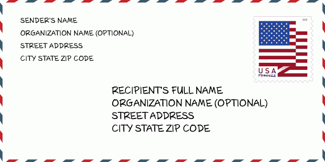
DAYTON ID 83232-5105
UNITED STATES OF AMERICA
83232-5105 Příklad obálky

-
Toto je příklad americké obálky. Vyplňte informace o odesílateli vlevo nahoře a informace o příjemci vpravo dole. Potřebné informace jsou úplné jméno odesílatele/příjemce, adresa, město, stát a PSČ. Informace o adrese příjemce byly poskytnuty pro vaši informaci. Obecně platí, že pokud si nejste jisti úplným 9místným PSČ, můžete vyplnit pouze 5místné PSČ, aby nedošlo ke ztrátě balíčku.
83232-5105 Základní význam
-
Co znamená každá číslice PSČ 83232-5105? PSČ se skládá ze dvou částí, prvních pět číslic může být umístěno na poštu a poslední čtyři číslice mohou identifikovat geografický segment v rámci pětimístné oblasti doručení. 6-7 číslic označuje sektor nebo několik bloků a 8-9 číslic označuje segment nebo jednu stranu ulice.
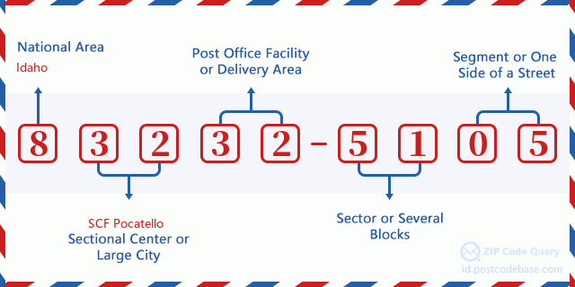

- ·Číslo trasy dopravce?
A 4-digit code assigned to a mail delivery or collection route within a 5-digit ZIP Code. The first character of this identification is alphabetical, and the last three are numeric: Bnnn = PO box Hnnn = Highway contract Rnnn = Rural route Cnnn = City delivery Gnnn = General delivery: H073 (Dopravce po dálnicích)
- ·Doplněk PSČ nízkého sektoru?
The ZIP Add-On Low Sector and the ZIP Add-On Low Segment together form the ZIP Add-On Low Number. The ZIP Add-On Low Number is the last four positions of a ZIP+4 code; the low-end ZIP add-on in a range of codes; the add-on of the first ZIP+4 code in a consecutive series of ZIP+4 codes assigned to the delivery address. For example, most delivery addresses are assigned a single ZIP+4 code. However, large companies may be given a range of ZIP+4 codes that can be used to route mail to specific departments. A range of ZIP+4 codes can also be assigned to a corresponding range of post office boxes, and each box is mapped, one-to-one, with a ZIP+4 code in the range. A single post office box can also be assigned a range of ZIP+4 codes.: 51
- ·Doplněk PSČ nízkého segmentu?
The ZIP Add-On Low Sector and the ZIP Add-On Low Segment together form the ZIP Add-On Low Number. The ZIP Add-On Low Number is the last four positions of a ZIP+4 code; the low-end ZIP add-on in a range of codes; the add-on of the first ZIP+4 code in a consecutive series of ZIP+4 codes assigned to the delivery address. For example, most delivery addresses are assigned a single ZIP+4 code. However, large companies may be given a range of ZIP+4 codes that can be used to route mail to specific departments. A range of ZIP+4 codes can also be assigned to a corresponding range of post office boxes, and each box is mapped, one-to-one, with a ZIP+4 code in the range. A single post office box can also be assigned a range of ZIP+4 codes.: 05
- ·Doplněk PSČ vysokého sektoru?
The ZIP Add-On High Sector and the ZIP Add-On High Segment together form the ZIP Add-On High Number, which is the high-end ZIP add-on in a range of codes; the add-on of the last ZIP+4 code in a consecutive series of ZIP+4 codes assigned to the delivery address. Most delivery addresses are assigned a single ZIP+4 code; however, large companies may be given a range of ZIP+4 codes that can be used to route mail to specific departments. A range of ZIP+4 codes can also be assigned to a corresponding range of post office boxes, and each box is mapped, one-to-one, with a ZIP+4 code in the range. A single post office box can also be assigned a range of ZIP+4 codes. (See also ZIP Add-On Code.): 51
- ·Doplněk PSČ vysokého segmentu?
The ZIP Add-On High Sector and the ZIP Add-On High Segment together form the ZIP Add-On High Number, which is the high-end ZIP add-on in a range of codes; the add-on of the last ZIP+4 code in a consecutive series of ZIP+4 codes assigned to the delivery address. Most delivery addresses are assigned a single ZIP+4 code; however, large companies may be given a range of ZIP+4 codes that can be used to route mail to specific departments. A range of ZIP+4 codes can also be assigned to a corresponding range of post office boxes, and each box is mapped, one-to-one, with a ZIP+4 code in the range. A single post office box can also be assigned a range of ZIP+4 codes. (See also ZIP Add-On Code.): 05
- ·PSČ Dodatek: 5105
- ·Rozsah?
The range of +4 codes. Summing the +4 Code and the +4 Range will give you the high end of the range of +4 Codes that pertain to this ZIP Code.: 0
- ·Základní alternativní kód?
Code that specifies whether a record is a base (preferred) or alternate record. Base records (represented as "B") can represent a range of addresses or an individual address, such as a firm record, while alternate records (represented as "A") are individual delivery points. Government deliveries will only be listed on alternate records with the appropriate government building indicator (federal, state, or city) set.: Základní
- ·Finanční číslo?
A code assigned to Postal Service facilities (primarily post offices) to collect cost and statistical data and compile revenue and expense data. The state number comprises the first two positions of the finance number.: 152250
- ·Číslo kongresového okresu?
A standard value identifying a geographic area within the United States served by a member of the US House of Representatives or Senate. If Army/Air Force (APO) or fleet post office (FPO), this column will be blank. If there is only one member of Congress within a state, the code will be "AL" (at large).: 02
- ·Preferovaný městský státní klíč?
An index to the City State file that provides the preferred last-line name for this address range.: Z12508
Online mapa

Toto je online mapa adresy 2600 N (North) WESTSIDE HWY, DAYTON. Pro posun a přiblížení/oddálení použijte tlačítko. Informace z mapy jsou pouze pro orientaci.
Adresa: 2600 (From 2600 To 2699) N (North) WESTSIDE HWY, DAYTON, ID 83232-5105, USA
Komentář


Přidat komentář