Address: 700 (From 700 To 799) E (East) 400 N (North), FIRTH, ID 83236-1246, USA
What's 83236-1246? 83236-1246 is a ZIP Code 5 Plus 4 number of 700 (From 700 To 799) E (East) 400 N (North), FIRTH, ID, USA. Below is detail information.
83236-1246 Basic Information

-
ZIP Code 5 Plus 4:
83236-1246 -
ZIP Code 5:
83236 -
Plus 4?12464-digits that are used to identify a geographic segment within the 5-digit delivery area, such as a city block or a group of apartments or an individual high-volume receiver of mail, or any other unit that could use an extra identifier to aid in efficient mail sorting and delivery. This code is the low end of the range of +4 Codes that pertain to this ZIP Code. ZIP+4 Codes associated with nondelivery areas are composed of valid ZIP sector numbers and "ND" for the ZIP segment number, for example 12345-12ND. Non-deliverable areas are areas to which the USPS does not deliver mail, such as vacant lots and land that borders railroad tracks. Mailers should not match an address identified as a nondelivery area. If you absolutely must have numeric characters in the Plus4Code column, you may treat "ND" values as "00" (zero zero).:
-
Country:
U.S. - United States -
State:
ID - Idaho -
County:
CountyFIPS: 16011 - Bingham County -
City:
FIRTH -
Street Predirectional:
E (East) -
Street?400The official name of a street as assigned by a local governing authority. The Street Name column contains only the street name and does not include directionals (EAST, WEST, etc.) or suffixes (ST, DR, BLVD, etc.). This element may also contain literals, such as PO BOX, GENERAL DELIVERY, USS, PSC, or UNIT. Numeric street names that have numeric components that are four characters (or less) in length at are justified such that the low-order digit of the number is positioned in the fourth position of the street name column. This shift is made so that the numeric street names appear in numeric sequence.:
-
Street Postdirectional?N (North)A geographic direction that precedes the street name. For Example: 472 MAIN ST N Street Pre-Direction Abbreviation = N Spaces = No pre-direction N = North NE = Northeast E = East SE = Southeast S = South SW = Southwest W = West NW = Northwest:
-
Record Type?S: StreetAn alphabetic value that identifies the type of data in the record. Record type codes include the following: G = General delivery H = Highrise F = Firm S = Street P = PO box R = Rural route/highway contract:
Address

- Address Primary Low Number?
A house, rural route, highway contract box, or post office box number; the numeric or alphanumeric component of an address preceding the street name; the low-end address in a range of addresses. Often referred to as house number.: 700
- Address Primary High Number?
A house, rural route, contract box, or Post Office box number. The numeric or alphanumeric component of an address preceding the street name. The high-end address in a range of addresses. Often referred to as house number.: 799
- Address Primary Odd / Even Code?
Code that identifies the side or sides of a street for which a given address range is applicable. For street, highrise, firm and multi-carrier records, B = Both sides of a street, E = Even side of a street (even-numbered addresses in the range); O = Odd side of a street (odd-numbered addresses in the range). For general delivery, post office box, and rural route/highway contract records, this code will always be "B" (both).: Both of Odd and Even
- Primary Range: 700, 701, 702, 703, 704, 705, 706, 707, 708, 709, 710, 711, 712, 713, 714, 715, 716, 717, 718, 719, 720, 721, 722, 723, 724, 725, 726, 727, 728, 729, 730, 731, 732, 733, 734, 735, 736, 737, 738, 739, 740, 741, 742, 743, 744, 745, 746, 747, 748, 749, 750, 751, 752, 753, 754, 755, 756, 757, 758, 759, 760, 761, 762, 763, 764, 765, 766, 767, 768, 769, 770, 771, 772, 773, 774, 775, 776, 777, 778, 779, 780, 781, 782, 783, 784, 785, 786, 787, 788, 789, 790, 791, 792, 793, 794, 795, 796, 797, 798, 799.
Please click the "More Address Examples" to view the whole list.
700 E (East) 400 N (North), FIRTH, ID 83236-1246
701 E (East) 400 N (North), FIRTH, ID 83236-1246
702 E (East) 400 N (North), FIRTH, ID 83236-1246
703 E (East) 400 N (North), FIRTH, ID 83236-1246
704 E (East) 400 N (North), FIRTH, ID 83236-1246
705 E (East) 400 N (North), FIRTH, ID 83236-1246
706 E (East) 400 N (North), FIRTH, ID 83236-1246
707 E (East) 400 N (North), FIRTH, ID 83236-1246
708 E (East) 400 N (North), FIRTH, ID 83236-1246
709 E (East) 400 N (North), FIRTH, ID 83236-1246
710 E (East) 400 N (North), FIRTH, ID 83236-1246
711 E (East) 400 N (North), FIRTH, ID 83236-1246
712 E (East) 400 N (North), FIRTH, ID 83236-1246
713 E (East) 400 N (North), FIRTH, ID 83236-1246
714 E (East) 400 N (North), FIRTH, ID 83236-1246
715 E (East) 400 N (North), FIRTH, ID 83236-1246
716 E (East) 400 N (North), FIRTH, ID 83236-1246
717 E (East) 400 N (North), FIRTH, ID 83236-1246
718 E (East) 400 N (North), FIRTH, ID 83236-1246
719 E (East) 400 N (North), FIRTH, ID 83236-1246
720 E (East) 400 N (North), FIRTH, ID 83236-1246
721 E (East) 400 N (North), FIRTH, ID 83236-1246
722 E (East) 400 N (North), FIRTH, ID 83236-1246
723 E (East) 400 N (North), FIRTH, ID 83236-1246
724 E (East) 400 N (North), FIRTH, ID 83236-1246
725 E (East) 400 N (North), FIRTH, ID 83236-1246
726 E (East) 400 N (North), FIRTH, ID 83236-1246
727 E (East) 400 N (North), FIRTH, ID 83236-1246
728 E (East) 400 N (North), FIRTH, ID 83236-1246
729 E (East) 400 N (North), FIRTH, ID 83236-1246
730 E (East) 400 N (North), FIRTH, ID 83236-1246
731 E (East) 400 N (North), FIRTH, ID 83236-1246
732 E (East) 400 N (North), FIRTH, ID 83236-1246
733 E (East) 400 N (North), FIRTH, ID 83236-1246
734 E (East) 400 N (North), FIRTH, ID 83236-1246
735 E (East) 400 N (North), FIRTH, ID 83236-1246
736 E (East) 400 N (North), FIRTH, ID 83236-1246
737 E (East) 400 N (North), FIRTH, ID 83236-1246
738 E (East) 400 N (North), FIRTH, ID 83236-1246
739 E (East) 400 N (North), FIRTH, ID 83236-1246
740 E (East) 400 N (North), FIRTH, ID 83236-1246
741 E (East) 400 N (North), FIRTH, ID 83236-1246
742 E (East) 400 N (North), FIRTH, ID 83236-1246
743 E (East) 400 N (North), FIRTH, ID 83236-1246
744 E (East) 400 N (North), FIRTH, ID 83236-1246
745 E (East) 400 N (North), FIRTH, ID 83236-1246
746 E (East) 400 N (North), FIRTH, ID 83236-1246
747 E (East) 400 N (North), FIRTH, ID 83236-1246
748 E (East) 400 N (North), FIRTH, ID 83236-1246
749 E (East) 400 N (North), FIRTH, ID 83236-1246
750 E (East) 400 N (North), FIRTH, ID 83236-1246
751 E (East) 400 N (North), FIRTH, ID 83236-1246
752 E (East) 400 N (North), FIRTH, ID 83236-1246
753 E (East) 400 N (North), FIRTH, ID 83236-1246
754 E (East) 400 N (North), FIRTH, ID 83236-1246
755 E (East) 400 N (North), FIRTH, ID 83236-1246
756 E (East) 400 N (North), FIRTH, ID 83236-1246
757 E (East) 400 N (North), FIRTH, ID 83236-1246
758 E (East) 400 N (North), FIRTH, ID 83236-1246
759 E (East) 400 N (North), FIRTH, ID 83236-1246
760 E (East) 400 N (North), FIRTH, ID 83236-1246
761 E (East) 400 N (North), FIRTH, ID 83236-1246
762 E (East) 400 N (North), FIRTH, ID 83236-1246
763 E (East) 400 N (North), FIRTH, ID 83236-1246
764 E (East) 400 N (North), FIRTH, ID 83236-1246
765 E (East) 400 N (North), FIRTH, ID 83236-1246
766 E (East) 400 N (North), FIRTH, ID 83236-1246
767 E (East) 400 N (North), FIRTH, ID 83236-1246
768 E (East) 400 N (North), FIRTH, ID 83236-1246
769 E (East) 400 N (North), FIRTH, ID 83236-1246
770 E (East) 400 N (North), FIRTH, ID 83236-1246
771 E (East) 400 N (North), FIRTH, ID 83236-1246
772 E (East) 400 N (North), FIRTH, ID 83236-1246
773 E (East) 400 N (North), FIRTH, ID 83236-1246
774 E (East) 400 N (North), FIRTH, ID 83236-1246
775 E (East) 400 N (North), FIRTH, ID 83236-1246
776 E (East) 400 N (North), FIRTH, ID 83236-1246
777 E (East) 400 N (North), FIRTH, ID 83236-1246
778 E (East) 400 N (North), FIRTH, ID 83236-1246
779 E (East) 400 N (North), FIRTH, ID 83236-1246
780 E (East) 400 N (North), FIRTH, ID 83236-1246
781 E (East) 400 N (North), FIRTH, ID 83236-1246
782 E (East) 400 N (North), FIRTH, ID 83236-1246
783 E (East) 400 N (North), FIRTH, ID 83236-1246
784 E (East) 400 N (North), FIRTH, ID 83236-1246
785 E (East) 400 N (North), FIRTH, ID 83236-1246
786 E (East) 400 N (North), FIRTH, ID 83236-1246
787 E (East) 400 N (North), FIRTH, ID 83236-1246
788 E (East) 400 N (North), FIRTH, ID 83236-1246
789 E (East) 400 N (North), FIRTH, ID 83236-1246
790 E (East) 400 N (North), FIRTH, ID 83236-1246
791 E (East) 400 N (North), FIRTH, ID 83236-1246
792 E (East) 400 N (North), FIRTH, ID 83236-1246
793 E (East) 400 N (North), FIRTH, ID 83236-1246
794 E (East) 400 N (North), FIRTH, ID 83236-1246
795 E (East) 400 N (North), FIRTH, ID 83236-1246
796 E (East) 400 N (North), FIRTH, ID 83236-1246
797 E (East) 400 N (North), FIRTH, ID 83236-1246
798 E (East) 400 N (North), FIRTH, ID 83236-1246
799 E (East) 400 N (North), FIRTH, ID 83236-1246
Address Example
FIRTH ID 83236-1246
UNITED STATES OF AMERICA
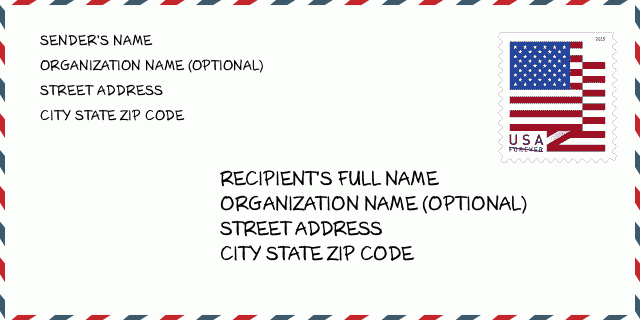
83236-1246 Envelope Example

-
This is an example of U.S envelope. Fill in the sender's information at the top left and the recipient information at the bottom right. The necessary information is sender/recipient's full name, street address, city, state and zip code. The recipient address information has been given for your reference. Generally, If you are not sure of the full 9-digit zip code, you can only fill in the 5-digit zip code to avoid loss of package.
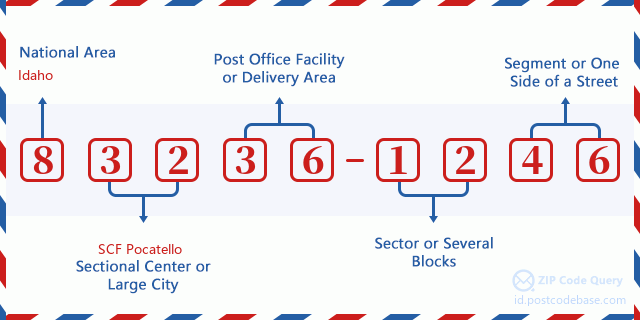
83236-1246 Basic Meaning
-
What does each digit of ZIP Code 83236-1246 stands for? ZIP+4 Code consists of two parts, the first five digits can be located to the post office, and the last four digits can identify a geographic segment within the five-digit delivery area. The 6-7 digits designate sector or several blocks, and the 8-9 digits designate segment or one side of a street.

- ·Carrier Route ID?
A 4-digit code assigned to a mail delivery or collection route within a 5-digit ZIP Code. The first character of this identification is alphabetical, and the last three are numeric: Bnnn = PO box Hnnn = Highway contract Rnnn = Rural route Cnnn = City delivery Gnnn = General delivery: R001 (Rural route)
- ·ZIP Add-On Low Sector?
The ZIP Add-On Low Sector and the ZIP Add-On Low Segment together form the ZIP Add-On Low Number. The ZIP Add-On Low Number is the last four positions of a ZIP+4 code; the low-end ZIP add-on in a range of codes; the add-on of the first ZIP+4 code in a consecutive series of ZIP+4 codes assigned to the delivery address. For example, most delivery addresses are assigned a single ZIP+4 code. However, large companies may be given a range of ZIP+4 codes that can be used to route mail to specific departments. A range of ZIP+4 codes can also be assigned to a corresponding range of post office boxes, and each box is mapped, one-to-one, with a ZIP+4 code in the range. A single post office box can also be assigned a range of ZIP+4 codes.: 12
- ·ZIP Add-On Low Segment?
The ZIP Add-On Low Sector and the ZIP Add-On Low Segment together form the ZIP Add-On Low Number. The ZIP Add-On Low Number is the last four positions of a ZIP+4 code; the low-end ZIP add-on in a range of codes; the add-on of the first ZIP+4 code in a consecutive series of ZIP+4 codes assigned to the delivery address. For example, most delivery addresses are assigned a single ZIP+4 code. However, large companies may be given a range of ZIP+4 codes that can be used to route mail to specific departments. A range of ZIP+4 codes can also be assigned to a corresponding range of post office boxes, and each box is mapped, one-to-one, with a ZIP+4 code in the range. A single post office box can also be assigned a range of ZIP+4 codes.: 46
- ·ZIP Add-On High Sector?
The ZIP Add-On High Sector and the ZIP Add-On High Segment together form the ZIP Add-On High Number, which is the high-end ZIP add-on in a range of codes; the add-on of the last ZIP+4 code in a consecutive series of ZIP+4 codes assigned to the delivery address. Most delivery addresses are assigned a single ZIP+4 code; however, large companies may be given a range of ZIP+4 codes that can be used to route mail to specific departments. A range of ZIP+4 codes can also be assigned to a corresponding range of post office boxes, and each box is mapped, one-to-one, with a ZIP+4 code in the range. A single post office box can also be assigned a range of ZIP+4 codes. (See also ZIP Add-On Code.): 12
- ·ZIP Add-On High Segment?
The ZIP Add-On High Sector and the ZIP Add-On High Segment together form the ZIP Add-On High Number, which is the high-end ZIP add-on in a range of codes; the add-on of the last ZIP+4 code in a consecutive series of ZIP+4 codes assigned to the delivery address. Most delivery addresses are assigned a single ZIP+4 code; however, large companies may be given a range of ZIP+4 codes that can be used to route mail to specific departments. A range of ZIP+4 codes can also be assigned to a corresponding range of post office boxes, and each box is mapped, one-to-one, with a ZIP+4 code in the range. A single post office box can also be assigned a range of ZIP+4 codes. (See also ZIP Add-On Code.): 46
- ·ZIP Code Add On: 1246
- ·Range?
The range of +4 codes. Summing the +4 Code and the +4 Range will give you the high end of the range of +4 Codes that pertain to this ZIP Code.: 0
- ·Base Alternate Code?
Code that specifies whether a record is a base (preferred) or alternate record. Base records (represented as "B") can represent a range of addresses or an individual address, such as a firm record, while alternate records (represented as "A") are individual delivery points. Government deliveries will only be listed on alternate records with the appropriate government building indicator (federal, state, or city) set.: Base
- ·Finance Number?
A code assigned to Postal Service facilities (primarily post offices) to collect cost and statistical data and compile revenue and expense data. The state number comprises the first two positions of the finance number.: 153100
- ·Congressional District Number?
A standard value identifying a geographic area within the United States served by a member of the US House of Representatives or Senate. If Army/Air Force (APO) or fleet post office (FPO), this column will be blank. If there is only one member of Congress within a state, the code will be "AL" (at large).: 02
- ·Preferred Last Line City State Key?
An index to the City State file that provides the preferred last-line name for this address range.: Z12559
Online Map

This is online map of the address 700 E (East) 400 FIRTH. You may use button to move and zoom in / out. The map information is for reference only.
Address: 700 (From 700 To 799) E (East) 400 N (North), FIRTH, ID 83236-1246, USA
Comment


Add new comment